

Garmin Montana 750i
Rugged GPS Touchscreen Navigator with inReach®
Technology and 8 Megapixel Camera

Garmin Montana 750i
Rugged GPS Touchscreen Navigator with inReach® Technology and 8 Megapixel Camera
SEE THE WORLD. STAY IN TOUCH. BE THE PICTURE OF ADVENTURE.
The rugged Montana 750i handheld combines the flexibility of on- or off-road navigation with global messaging and interactive SOS via inReach satellite technology1 — plus a built-in 8-megapixel camera.
Specifications:
- Big news. A full QWERTY keyboard lets you easily type messages.
- Wander wider and still stay in touch — with inReach for messaging and 24/7 SOS.
- Nav, meet cam. Put your trip pics on the map with geotags.
- Routable TopoActive Africa maps. Now you’re free to take it off-road or on.
- Meets MIL-STD 810 for thermal, shock, water and vibration.
- Power your adventures with 18+ hours of lithium-ion battery life in GPS mode.
TWO-WAY MESSAGING
Exchange text messages with loved ones, post to social media, or communicate via inReach device to inReach device in the field (active satellite subscription required).
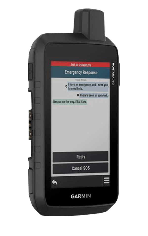
INTERACTIVE SOS
In case of emergency, trigger an interactive SOS message to GEOS, the Garmin-powered International Emergency Response Coordination Centre (IERCC) with professional 24/7 global monitoring and response centre (active satellite subscription required).
GLOBAL CONNECTIVITY
Instead of relying on cellphone coverage, now your messages, SOS and tracking are transferred via the 100% global Iridium® satellite network (active satellite subscription required).


INREACH WEATHER
Available inReach weather forecast service provides detailed updates directly to your Montana handheld or paired devices, so you’ll know what to expect en route.
RUGGED BY DESIGN
This durable, water-resistant handheld is tested to U.S. military standards and features a glove-friendly 5” touchscreen that’s 50% larger than previous Montana models.
BUILT-IN CAMERA
Capture images of your exploits with Montana’s digital 8-megapixel camera. It geotags photos with coordinates, so you can navigate back to favourite sites in the future.
CITY NAVIGATOR MAPS
Seamlessly transition from trails to road navigation with preloaded City Navigator street mapping, which guides your drive with easy-to-follow turn-by-turn directions.
TOPOACTIVE AFRICA MAPS
To navigate your adventures, use preloaded TopoActive Africa maps. View elevations, coastlines, rivers, landmarks and more.
SATELLITE VIEWS
Use direct-to-device downloads of BirdsEye Satellite Imagery (no annual subscription required) to see photo-realistic views and create waypoints based on landmarks.
ABC SENSORS
Navigate your next trail with ABC sensors, including an altimeter for elevation data, barometer to monitor weather and 3-axis electronic compass.
ACTIVE WEATHER
Use cellular connectivity2 to access up-to-date Active Weather forecasts through the Garmin Connect™ app.
SEE THE WORLD. STAY IN TOUCH. BE THE PICTURE OF ADVENTURE.
The rugged Montana 750i handheld combines the flexibility of on- or off-road navigation with global messaging and interactive SOS via inReach satellite technology1 — plus a built-in 8-megapixel camera.
Specifications:
- Big news. A full QWERTY keyboard lets you easily type messages.
- Wander wider and still stay in touch — with inReach for messaging and 24/7 SOS.
- Nav, meet cam. Put your trip pics on the map with geotags.
- Routable TopoActive Africa maps. Now you’re free to take it off-road or on.
- Meets MIL-STD 810 for thermal, shock, water and vibration.
- Power your adventures with 18+ hours of lithium-ion battery life in GPS mode.
TWO-WAY MESSAGING
Exchange text messages with loved ones, post to social media, or communicate via inReach device to inReach device in the field (active satellite subscription required).
INTERACTIVE SOS
In case of emergency, trigger an interactive SOS message to GEOS, the Garmin-powered International Emergency Response Coordination Centre (IERCC) with professional 24/7 global monitoring and response centre (active satellite subscription required).
GLOBAL CONNECTIVITY
Instead of relying on cellphone coverage, now your messages, SOS and tracking are transferred via the 100% global Iridium® satellite network (active satellite subscription required).
INREACH WEATHER
Available inReach weather forecast service provides detailed updates directly to your Montana handheld or paired devices, so you’ll know what to expect en route.
RUGGED BY DESIGN
This durable, water-resistant handheld is tested to U.S. military standards and features a glove-friendly 5” touchscreen that’s 50% larger than previous Montana models.
BUILT-IN CAMERA
Capture images of your exploits with Montana’s digital 8-megapixel camera. It geotags photos with coordinates, so you can navigate back to favourite sites in the future.
CITY NAVIGATOR MAPS
Seamlessly transition from trails to road navigation with preloaded City Navigator street mapping, which guides your drive with easy-to-follow turn-by-turn directions.
TOPOACTIVE AFRICA MAPS
To navigate your adventures, use preloaded TopoActive Africa maps. View elevations, coastlines, rivers, landmarks and more.
SATELLITE VIEWS
Use direct-to-device downloads of BirdsEye Satellite Imagery (no annual subscription required) to see photo-realistic views and create waypoints based on landmarks.
ABC SENSORS
Navigate your next trail with ABC sensors, including an altimeter for elevation data, barometer to monitor weather and 3-axis electronic compass.
ACTIVE WEATHER
Use cellular connectivity2 to access up-to-date Active Weather forecasts through the Garmin Connect™ app.